Large spaces, clearly mapped.
Large spaces, clearly mapped.
Large spaces, clearly mapped.
Maps, wayfinding, and signage systems for events, attractions, and visitor environments.


Trusted by over 150+ independent sites


Explore our projects
Explore selected projects across education, estates, visitor attractions, events and more.


Trusted by over 150+ Independent sites

Explore our projects
Explore selected projects across education, estates, visitor attractions, events and more. From compact campuses to expansive visitor destinations, every map is designed to make a place easier to understand, navigate and experience.
Trusted by over 150+ Independent sites


Explore our projects
Explore selected projects across education, estates, visitor attractions, events and more. From compact campuses to expansive visitor destinations, every map is designed to make a place easier to understand, navigate and experience.
One map, multiple uses
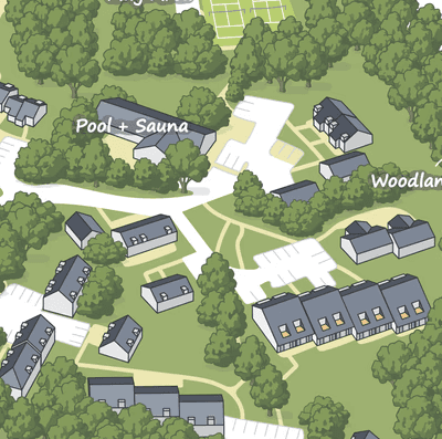
The core map is designed as a reusable asset. From the same visual system, we can create versions for entrance boards, websites, printed guides, arrival emails and location-specific signage.

Build the map once. Adapt it wherever visitors need it.
Benefits
Maps made for real places…
We create illustrated maps, wayfinding systems and digital experiences for complex spaces, designed to make places easier to understand, navigate and experience.
We’ve had so many people comment on how good the map looks. It’s much easier for visitors to find their way around, and it’s something we’re genuinely proud to put our name on.
These guys really understood what we needed. There’s a lot going on across the site, but the finished map makes it feel much simpler and easier to navigate.
The detail is honestly brilliant. We can point people to pretty much anything on site, and it still doesn’t feel cluttered or confusing.
It’s made a big difference to how we show people around the site. We’ve already found ourselves using the map for things we hadn’t originally thought about.
We gave them quite a complicated site to work with and he managed to turn it into something that actually feels really easy to understand.
Wayfinding
Clear routes, destinations and visitor information.
Digital Maps
Maps made for websites and QR-linked experiences.
Map Systems
One master map adapted across multiple applications.
Wayfinding
Clear routes, destinations and visitor information.
Digital Maps
Maps made for websites and QR-linked experiences.
Map Systems
One master map adapted across multiple applications.
Updated whenever.
Buildings change, facilities move and event layouts evolve. Existing clients can reserve annual or seasonal update slots without commissioning a new map from the beginning.
About us
Forty Four Maps is an independent visitor-mapping and wayfinding studio founded in Cornwall.
Every project is designed directly with the person producing the map. That means clearer communication, careful attention to the site and a visual result tailored to the organisation rather than selected from a generic template.
The work combines accurate site structure, considered visual hierarchy and distinctive illustration to make complex places easier to understand.
Benefits
Maps made for real places…
We create illustrated maps, wayfinding systems and digital experiences for complex spaces, designed to make places easier to understand, navigate and experience.
We’ve had so many people comment on how good the map looks. It’s much easier for visitors to find their way around, and it’s something we’re genuinely proud to put our name on.
These guys really understood what we needed. There’s a lot going on across the site, but the finished map makes it feel much simpler and easier to navigate.
The detail is honestly brilliant. We can point people to pretty much anything on site, and it still doesn’t feel cluttered or confusing.
It’s made a big difference to how we show people around the site. We’ve already found ourselves using the map for things we hadn’t originally thought about.
We gave them quite a complicated site to work with and they managed to turn it into something that actually feels really easy to understand.
One map, multiple uses
The core map is designed as a reusable asset. From the same visual system, we can create versions for entrance boards, websites, printed guides, arrival emails and location-specific signage.
Build the map once. Adapt it wherever visitors need it.
One map, multiple uses
The core map is designed as a reusable asset. From the same visual system, we can create versions for entrance boards, websites, printed guides, arrival emails and location-specific signage.
Build the map once. Adapt it wherever visitors need it.
Benefits
Maps made for real places…
We create illustrated maps, wayfinding systems and digital experiences for complex spaces, designed to make places easier to understand, navigate and experience.
We’ve had so many people comment on how good the map looks. It’s much easier for visitors to find their way around, and it’s something we’re genuinely proud to put our name on.
These guys really understood what we needed. There’s a lot going on across the site, but the finished map makes it feel much simpler and easier to navigate.
The detail is honestly brilliant. We can point people to pretty much anything on site, and it still doesn’t feel cluttered or confusing.
It’s made a big difference to how we show people around the site. We’ve already found ourselves using the map for things we hadn’t originally thought about.
We gave them quite a complicated site to work with and he managed to turn it into something that actually feels really easy to understand.
Wayfinding
Clear routes, destinations and visitor information.
Digital Maps
Maps made for websites and QR-linked experiences.
Map Systems
One master map adapted across multiple applications.
The quality has been exceptional throughout all their projects for Offset. Their creative approach, attention to detail, and ability to translate concepts into striking visuals have consistently exceeded expectations. We highly recommend 44 and are happy to stand as a reference for future clients. Offset Show will also continue working with them for many years to come.
Brad Stone
Offset Show

Updated whenever.
Updated whenever.
Buildings change, facilities move and event layouts evolve. Existing clients can reserve annual or seasonal update slots without commissioning a new map from the beginning.
About us
About us
Forty Four Maps is an independent visitor-mapping and wayfinding studio founded in Cornwall.
Every project is designed directly with the person producing the map. That means clearer communication, careful attention to the site and a visual result tailored to the organisation rather than selected from a generic template.
The work combines accurate site structure, considered visual hierarchy and distinctive illustration to make complex places easier to understand.